Mississippi State University Weather

Warm Temperatures, Storms Likely For Super Bulldog Weekend

Warm Temperatures, Storms Likely For Super Bulldog Weekend

Apr 18, 2024

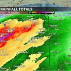
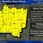
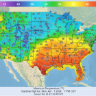
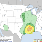
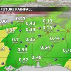
If you haven’t been a fan of the above normal temperatures, you’re in luck. Some relief is on the way but, you will just have to wait a few more days. Temperatures will continue to be above normal until this weekend, as highs will dip into the upper 50s for Sunday. These will be below average for this time of the year. TODAY AND TONIGHT Spotty showers are still expected during the late afternoon hours. It won’t be a total washout as you’re heading home for your evening commute or sporting activities. Tonight, a cold front moves into the region giving way to some thunderstorms. Lows tonight will dip into the upper 50s. These storms do have the potential to be severe, as the Storm Prediction Center has a marginal risk put out for the area. Damaging winds and heavy rain are the main threats. SUPER BULLDOG WEEKEND The 3-game series between Mississippi State and Auburn baseball is expected to begin at 6pm on Friday. First pitch, you can expect mostly cloudy skies. So, a light sweater might be suitable as the winds may cause the temps to feel a degree or two colder. Low temperatures will reach the 60s with a north wind at 5 mph. Saturday into Sunday, rain percentages will range from 50-70%, so be sure to bring an umbrella or jacket as you’re heading out to any of the sporting events. After these rounds of showers and thunderstorms over the weekend, a high pressure will gradually begin to slide into the region Sunday. This is bringing dry conditions and cool temperatures into Monday with lows being in the 40s. Temperatures begin to warm back up to near and above average early next...

Soggy and Windy Thursday, But Sunny Weekend Ahead!

Soggy and Windy Thursday, But Sunny Weekend Ahead!

Apr 11, 2024

TODAY AND TONIGHT After a rather rainy and stormy beginning to our workweek, we finally are seeing the light at the end of the tunnel! Northeast Mississippi has seen lots of rain over the past 24 hours, with the bulk of the rain totals in the western portion of our viewing area. Grenada and northern parts of Winona received over 7.5 inches of rain! Starkville received just over 2.5 inches of rain, and this is on top of what we already received Monday and Tuesday! Although we are out of the flood watch, it is important to remember the saying, “turn around, don’t drown”, when approaching flooded roads. A cold front will pass through during the afternoon hours, which will push any leftover rain showers out to our southeast. As the front passes, wind gusts will start to pick up, gusting over 30 mph throughout our viewing area. During the later part of the afternoon, we could see some of the greatly missed sunshine peep through those clouds! This will be a great time to take those furry friends on a walk but be sure to grab a light jacket. Due to the passing front, temperatures will have a steady drop as we go into the nighttime hours, hitting the lower 60s by 6pm. Our overnight low will be in the mid to upper 40s, with clear skies and calming wind gusts. TOMORROW Due to a high-pressure system that will be coming from the west and stationing over parts of East Texas, Western Louisiana and along the gulf, we will start to see sunshine come into the forecast once again! High temperatures will hit 70°, with very limited cloud cover, if any at all. Overnight lows will once again drop into the mid 40s, due to clear skies and no cloud coverage being able to trap in the warmer air.  THE WEEKEND It will be all sunshine and rainbows for the weekend with temperatures increasing each day! High temperatures will near 80° on Saturday with partly cloudy skies. Sunday is when we will hit the lower 80s making it a nice day to sit out at the pool. EARLY NEXT WEEK Temperatures will continue to increase into...

Quiet Now, But Storms on the Way

Quiet Now, But Storms on the Way

Apr 4, 2024

TODAY AND TONIGHT We had a much cooler start to the day with a low in the 40s but warmed up to a more seasonable temperature hitting the mid 60s. The rest of the day will be sunny and mostly pleasant, except for some wind gusts that could reach up to 25 mph. Dry weather and gusty winds creates a limited fire weather risk for some portions of our viewing area, so be cautious of open burning this afternoon. Winds will calm through the overnight hours and there will be a significant cooldown to the upper 30s. Clear night skies will keep the temperature cooler.  CALM START TO THE WEEKEND Calm conditions are to be expected Friday through Saturday as a high-pressure system moves eastward through Northeast Mississippi. There will be plenty of sunshine on Friday, with warmer temperatures reaching the upper 60s. However, it will again be a chilly night in the low 40s. A warming trend will continue Saturday, reaching a high of 70. Much like Friday night, Saturday evening will still be cool, but low temperatures will be closer to the 50s. Calm conditions will persist through the night and the start of Sunday. Temperatures will warm up even more on Sunday, reaching the upper 70s. RAIN CHANCES INCREASING INTO THE WEEK Sunday will begin mostly sunny, but slight chances of rain will grow through the day as a low-pressure system approaches the Southeast. The main threat is scattered showers and thunderstorms that will begin after 1pm and will increase into the evening as cloud coverage builds. Scattered thunderstorms are likely through the night, and could be accompanied by some gusty winds of up to 25 mph. The low-pressure system will shift north at the start of the week, but a cold front will stall over the area and rain chances will continue to increase through Tuesday night, likely sticking around through Thursday. Precipitation chances on Monday are around 30%, but this will increase to 50% on Tuesday and Wednesday. The arrival of the cold front will drop temperatures a few degrees, but it will still be quite seasonable with highs in the mid 70s and lows in the 60s Monday...

Beautiful Easter Weekend Ahead

Beautiful Easter Weekend Ahead

Mar 28, 2024

Today we woke up to clear skies and seasonably cooler temperatures. Following these cooler temperatures is a warming trend. A high-pressure system is helping to keep the weather in our region quiet. The temperature will reach the upper 60s today with the wind coming from the north at 5-10 mph. The sky conditions will remain sunny without a cloud in the sky. This weather will persist for the rest of the week and into the weekend. As sunset approaches today, the sky will remain clear and the temperatures will reach a low in the upper 30s with calm winds. TEMPERATURES ON THE RISE As the week continues warm air advection is causing the temperatures to rise day-by-day. Friday is expected to be sunny and clear with the temperatures topping out in the lower 70’s. The sunset will bring about a possibility for some clouds to roll into the area. As the weekend nears, we are likely to experience temperatures in the 80s with sunny skies. Temperatures on Easter Sunday are projected to reach into the lower 80s at the peak of the day. Expect gusty conditions this weekend with winds coming from the south-southwest at 5-10mph with the possibility for gusts up to 20 mph. As the workweek begins, we should see partly sunny skies with temperatures in the mid- 80s. Monday is going to be the hottest day that we experience in the next week even though it will be mostly cloudy. THE NEXT RAINMAKER Early Tuesday morning comes the next possibility of rain. Showers and some storms are possible early Tuesday morning. With the warm weather and instability that has built up before the rainmaker, the chance of thunderstorms is enhanced. Specific details about the possibility of shear and instability of the atmosphere cannot be determined quite yet since the system is still a couple of days out. The main threats we’re watching right now are damaging straight line and flooding concerns. Severe weather can not be ruled out quite yet. Following the wet weather, we are expecting to see cooler than normal temperatures return to our area. LOOKING TOWARD THE FUTURE Despite the arrival of cooler temperatures after the rain system...

A Stormy Start to the Week, Clear Conditions By Midweek

A Stormy Start to the Week, Clear Conditions By Midweek

Mar 25, 2024

Today has been for the most part quiet and breezy, however rain and storms are starting to approach and move into the region surrounding Starkville, Mississippi quickly. The rain and storms are associated with a low pressure system that is approaching the area. This system will move through during the evening/night hours into the early morning hours tomorrow, bringing rain and storms with some being severe. Rain and storms will clear out by tomorrow afternoon, making way for sunny and clear conditions that will persist through the weekend and into next week. A STORMY START TO THE WEEK TONIGHT INTO TOMORROW AFTERNOON While temperatures have been sitting in the low to mid-60s throughout the day, gusty winds out of the southeast have helped to increase moisture ahead of the cold front that is expected to move through. As a result, a wind advisory is in effect. The characteristics of the environment are typical for a common early spring, as there is high shear and low CAPE (Convective Available Potential Energy) across the region. The main concern for Starkville, Mississippi with these storms is damaging winds, isolated tornadoes, sustained winds of 20+mph, and minor flooding. The main line of storms is expected to roll through between 9 PM and 1 AM, however rain before and after this line is likely. Flooding is only expected to occur in low lying areas and areas with poor drainage, and possibly near lakes and rivers around the area. Water levels in these bodies of water have receded since the last rainfall. It is suspected that the main severe impacts will stay just to the west of Starkville, with Starkville being on the fringe of the boundary between the enhanced and slight risk areas. Instead, the Severe Prediction Center elected to keep Starkville under a slight risk. However an isolated severe storm in or around Starkville cannot be ruled out. The main severe weather threat and the heaviest of the rain will end with the passage of the cold front making way for a temporary cool-off and dry weather throughout the area. CLEAR CONDITIONS STARTING TUESDAY NIGHT AND PERSISTING THROUGH THIS WEEKEND High pressure will begin to build behind the...

Rainy End to the Week, But a Beautiful Weekend Ahead

Rainy End to the Week, But a Beautiful Weekend Ahead

Mar 21, 2024

Friday morning, we will see some rain return to northeast Mississippi in the form of showers and possibly some more moderate rainfall. This is expected to move out by the evening. The rain totals will be greater with westward extent, with our area receiving anywhere from 0.25”-0.5” throughout the day. Temperatures to close the workweek will be in the lower 60s across the region, dropping only into the lower 50s at night, as the cloud cover will mediate the temperatures.  WEEKEND OUTLOOK This weekend will see temperatures return into the middle 60s on Saturday as we dry out from Friday’s rain, and possibly up to 70 in some areas on Sunday. With clear, sunny skies there should not be any weather-related dampers to any daytime activities for the first full weekend of spring. That said, winds may be gusty at times, with winds generally at 10-15 mph and gusts possibly above 20 mph, especially on Saturday. Low temperatures for Saturday will be in the upper 30s and Sunday’s lows will be much warmer in the middle 50s. The biggest caveat to outdoor activities this weekend will be the high pollen counts and possible smoke from controlled burns, which may cause problems for anyone with allergies or breathing issues.  NEXT WEEK  We will start out the workweek with an eye on the sky, as we have been placed in a slight risk (2/5) for severe weather on Monday. A low-pressure system will move into our region bringing chances for showers and storms, some with the potential to be severe. The main questions around this system revolve around how much warm, moist air can make it to the region. This is contributing to some uncertainty around the impacts of this system but keep a close eye for updates as details become clearer in the coming days. For now, rainfall and some thunderstorms appear very likely across our region Monday afternoon and evening as high temperatures on Monday approach 70 degrees.  Tuesday some residual showers and storms will be possible. With part of the day likely being cloudy, temperatures with top out at 71 degrees and bottom out at 47 degrees.  Wednesday, things will quiet down for...