Sep 18, 2023
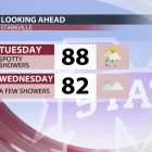
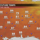
Our weather is on cruise control this week! A quiet weather pattern will take over, leaving us high and dry with consecutive sunny days. MONDAY NIGHT: Cool temperatures and calm winds. Patchy fog is possible before sunrise. Temperatures will dip into the mid-50s, so you might want to grab a hoodie or light jacket before leaving for those 8 a.m. classes. TUESDAY: It’ll feel cool and crisp outside again on Tuesday morning with temperatures in the mid and upper 50s! Patchy fog is possible, so keep that in mind on your commute to class. Once the fog lifts, it’s another beautiful day! Warm in the sun, but still comfortable. Temperatures will climb into the mid-80s on Tuesday afternoon. TUESDAY NIGHT: Another cool night! A few passing clouds overhead with lows in the upper 50s. REST OF THE WEEK: Beautiful! A little bit warmer on Wednesday, but upper 80s are the warmest we’ll get this week. Humidity will increase a little bit by mid-week as winds shift out of the south and east, but it won’t be a drastic change. You may not even feel a difference since moisture will still be limited. This will also keep rain chances out of the picture. We aren’t expecting any fronts or systems to impact our weather over the next six or seven days, so things look quiet for the rest of the week. Our next chance for rain won’t come until Sunday or early next week. We’re ok right now, but drought conditions could become an issue in the future, depending on how long this dry spell lasts. We’ll keep you posted! TROPICAL UPDATE: Hurricane Nigel is strengthening in the central Atlantic Ocean and could become a major hurricane by Tuesday. This storm is no threat to land and will curve out to sea later this week. The National Hurricane Center is monitoring two other disturbances in the Atlantic that could become tropical systems sometime over the next week, but neither of them are a threat to the Gulf Coast at this time. Have a great week, and Hail State! Dylan Hudler Student Meteorologist...