Feb 2, 2024
This warm and quiet week has come as a welcomed break following two weeks of active weather across the region. Our warmth peaked on Tuesday when highs exceeded 70°! Since then, a cold front has dropped temperatures into the 50s, but we will warm back into the 60s Friday and Saturday. Our dry streak ends on Sunday when a system brings rain back into the area.
Back Into The 60s On Friday
The high clouds that have been around for much of Thursday will clear slightly overnight. Temperatures will fall to around 40° Friday morning. This is roughly 10° warmer than the previous mornings this week, but you’ll still need a jacket to start the day! We will end the work week with another warm day. Highs will be roughly 10° above average on Friday as we climb into the mid-60s under mostly sunny skies.
The Weekend Starts Nice Before Rain Returns
Above average temperatures continue to start off the weekend. Saturday will start chilly with temperatures in the low-40s, but by the afternoon the mid-60s are back! Be sure to take advantage of the dry, spring- like weather because rain moves in before sunrise on Sunday. The high pressure that has kept us dry for much of the week will give way to a system that will pass to our south. Rain will persist for much of the day and could exceed an inch in spots. Generally, 0.75”-1.25” will be a safe bet. Due to the wet weather, Sunday will be cooler with highs in the mid-50s.
Seasonable Next Week
The most consistent rain should be out of the area by Monday, but lingering showers will remain possible, especially in the morning. Otherwise, most of next week looks dry! Temperatures will be seasonable with highs in the mid-50s and lows in the low to mid-30s. The next chance for rain does not look to arrive until the end of the week.
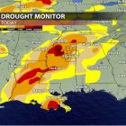
Drought Update
Following the repeated rounds of rain last week that brought a deluge to our area, a big dent was made in Mississippi’s drought! A new drought monitor was released today (2/1) and reflects the heavy rain we received. It is a great improvement from the previous drought map, but the highest level of drought is still present along I-55 in northern Mississippi. Hopefully the El Nino pattern we are currently in will continue to bring us wet weather that can chip away at our rainfall deficits!
Owen Basselman
Student Meteorologist