Mar 21, 2024
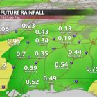
Friday morning, we will see some rain return to northeast Mississippi in the form of showers and possibly some more moderate rainfall. This is expected to move out by the evening. The rain totals will be greater with westward extent, with our area receiving anywhere from 0.25”-0.5” throughout the day. Temperatures to close the workweek will be in the lower 60s across the region, dropping only into the lower 50s at night, as the cloud cover will mediate the temperatures.
WEEKEND OUTLOOK
This weekend will see temperatures return into the middle 60s on Saturday as we dry out from Friday’s rain, and possibly up to 70 in some areas on Sunday. With clear, sunny skies there should not be any weather-related dampers to any daytime activities for the first full weekend of spring. That said, winds may be gusty at times, with winds generally at 10-15 mph and gusts possibly above 20 mph, especially on Saturday. Low temperatures for Saturday will be in the upper 30s and Sunday’s lows will be much warmer in the middle 50s. The biggest caveat to outdoor activities this weekend will be the high pollen counts and possible smoke from controlled burns, which may cause problems for anyone with allergies or breathing issues.
NEXT WEEK
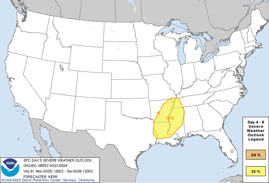
We will start out the workweek with an eye on the sky, as we have been placed in a slight risk (2/5) for severe weather on Monday. A low-pressure system will move into our region bringing chances for showers and storms, some with the potential to be severe. The main questions around this system revolve around how much warm, moist air can make it to the region. This is contributing to some uncertainty around the impacts of this system but keep a close eye for updates as details become clearer in the coming days. For now, rainfall and some thunderstorms appear very likely across our region Monday afternoon and evening as high temperatures on Monday approach 70 degrees.
Tuesday some residual showers and storms will be possible. With part of the day likely being cloudy, temperatures with top out at 71 degrees and bottom out at 47 degrees.
Wednesday, things will quiet down for northeast Mississippi. We will see lots of sunshine, and temperatures for Wednesday will increase into the lower 70s with temperatures dipping into the upper 40s overnight.
Thursday will be another characteristic spring day with highs in the upper 60s to low 70s and overnight lows in the upper 40s.
Overall, next week looks like a nice and seasonable week for all your activities, outside of the potential for severe weather and rain early in the week.
Charlie Goldstein
Student Meteorologist