Feb 15, 2024

Temperatures have warmed up nicely this week. Changes are on the way starting tonight. Clouds are beginning to build ahead of a cold front. The big story this weekend is the cold weather that will return.
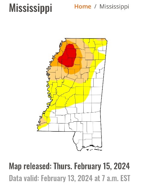
I want to start off with a story that our students have been highlighting for months—the extended period of drought. As of this morning, Mississippi’s drought has been almost eliminated. This is according to the latest map from the National Drought Mitigation Center. After 3” of rain this weekend in the Starkville area, Starkville is no longer categorized in any kind of drought. Late last year, 100% of the state was under at least a severe (2 out of 4) drought. 50% was under the worst category of drought (4 out of 4). Now, those numbers are 13% and 0% respectively.
SHORT TERM
Tonight will be mild. Temperatures on campus will fall to about 50°. Surrounding rural areas should fall between 45 and 47°. Normal for this time of year is 36°. Winds will become breezy from the south at about 10-15 mph as a front nears.
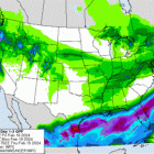
A Gulf Low will track to our south. This will help draw a quick-moving cold front over us Friday overnight. Mississippi State’s opening day for baseball against the Air Force should be dry, with temperatures near 70° and a cloudy sky. Most rain, as pictured, will be in the Gulf—maybe 0.25”-0.50” at best in northeast Mississippi.
If you have evening plans Friday, plan to keep a rain jacket handy. Rain – with maybe a rumble of thunder or two – will push in through the early dawn hours on Saturday. There’s a chance you are asleep while it passes over.
Saturday is not going to be a great baseball day. Some would call it football weather. Temperatures will struggle to get to the mid-40s. Highs will likely stay near 42°. It will be a raw day with clouds and breezy winds up to 20-25 mph. There will be nothing substantial rain-wise past about 8am.
The sun will come back out on Sunday. We will start off with the coldest temperatures we’ve had in weeks – the upper 20s. Highs will peak in the low 50s.
LONG TERM
High pressure will build in next week. Clear skies will hold. Monday morning will be especially chilly with lows in the mid-20s.
By Monday afternoon, temperatures will be near 60°. We will keep the warming trend going. By Friday, highs will climb to the lower 70s. It will be very mild.
There is a consistent pattern going on. The pattern is warmer for 4-5 days, and then there is a chance for rain. Afterwards, there is a brief return to cooler weather before it gets warmer once again.
Temperatures have been 4-5° above average so far this month. That should still be the case when we wrap it up on the 29th.
