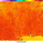
Mississippi State University Weather

Wetter Pattern for the Start of March

Wetter Pattern for the Start of March

Feb 29, 2024

Predicted rainfall totals over the next 7 days. Starkville, Mississippi could receive 1.25-1.75 inches of rainfall from Thursday-Wednesday. (February 29-March 6) REMAINDER OF TODAY: Temperatures have shifted to the cooler side since the start of the week. After starting the workweek with warmer temperatures, we are in the low 50s due to a strong cold front passing through yesterday, putting us well below the average high of 63. We are about ten degrees below that number with our Thursday high only hitting 54. Additionally, northeast winds gusting up to 20 mph are making it feel cooler than the low 50s. TONIGHT AND TOMORROW: The Golden Triangle area will continue to have cooler temperatures into the overnight hours, with a low of 43. A chance of rain is expected after midnight but predicted rainfall totals are only expected to accumulate to about a tenth of an inch for this round. However, Friday presents itself to be a rather wet day because of a low-pressure trough, bringing with it a decent amount of moisture. As a result, the chance of rain is 90%, along with some embedded thunderstorms being possible. High temperatures on Friday will top out in the mid-50s, with a low in the upper 40s. WEEKEND AHEAD: Thanks to dominating southerly winds, expect the first weekend of March to have warm days and comfortable nights. Temperatures during the day are expected to reach the 70s before dropping down to the 50s at night. Saturday will be our best day to be outside as we have minimal rain chances and mostly sunny skies. However, we will have some rain to deal with as we close out our weekend on Sunday, with the best chance of rain beginning in the afternoon hours. That rain will be widespread throughout all of Sunday afternoon, so be sure to keep an umbrella handy if you are going out for any activities. Weekend planner for this weekend in Starkville, Mississippi. Saturday looks to be the better day, with Sunday having showers and storms. WET PATTERN CONTINUES: WORKWEEK The beginning of next week starts relatively dreary, with those showers sticking with us through the early morning hours of Monday. You may...

Breezy Week Ahead with Rain and Cool Temperatures Making Return by Midweek

Breezy Week Ahead with Rain and Cool Temperatures Making Return by Midweek

Feb 26, 2024

Wind gusts in northeast Mississippi could exceed 30 mph, particularly on Tuesday. After a week of pleasant temperatures and dry conditions due to high pressure and upper-level ridging, change is coming to northeast Mississippi. A strong upper-level jet has resulted in the formation of an upper-level trough and low-pressure system followed by a strong cold front. This system is currently moving across western and midwestern portions of the United States. By Wednesday, it will make its way into northeast Mississippi bringing gusty winds, colder temperatures, and rainfall. Tonight and Tomorrow: Last week’s pattern of warm days, cool nights, and dry conditions will continue throughout this evening and Tuesday. Tonight, those low temperatures will be around 60, making for a comfortable evening. Winds could gust up to 25 mph, so it will be breezy. Cloud coverage will begin to increase late tonight and stick around through the rest of the workweek. Tuesday looks to be the warmest and most spring-like day that northeast Mississippi will have experienced this year with highs reaching near 80 and lows in the low 60s. Once again, strong wind gusts will be around, gusting up to 35 mph throughout the afternoon and evening. Other than being breezy, baseball conditions will be great for the Mississippi State game against Jackson State. Enjoy this weather on Tuesday while you can because Wednesday will start a period of more unsettled weather conditions and cooler temperatures. Remainder of Workweek: Wednesday will bring us our next major weathermaker. A low-pressure system will allow for the development of thunderstorms in Mississippi on Wednesday as it meets warm and moist air from the Gulf of Mexico. Currently, severe weather is not expected, but strong, gusty winds will continue to be an issue until the passage of the cold front. The main line of storms looks to arrive in northeast Mississippi in the early morning hours, with scattered showers sticking around throughout the rest of the day. As with Monday and Tuesday, wind gusts are expected to reach near 30 mph. Wednesday will be a warm day with temperatures peaking in the low 70s, but following the storm system’s exit will be low temperatures in the upper 30s...

From Warm to Warmer: Seasonal and Climatological pattern shifts reinforce spring temperatures

From Warm to Warmer: Seasonal and Climatological pattern shifts reinforce spring temperatures

Feb 22, 2024

Tonight and Tomorrow: A quick-moving cold front will deliver scattered showers and the potential for a couple of strong storms late tonight into the early morning hours of Friday. The Storm Prediction Center (SPC) has placed north Mississippi underneath a (⅕) marginal risk for severe storms as a couple of storms have the potential to produce strong winds. Once the front moves through northeast Mississippi, it will reinforce dry, sunny, and breezy conditions on Friday and into the weekend. Winds will shift from the north around 10 mph with gusts near 20 mph. Friday afternoon, high temperatures should climb into the mid-to-upper 60s. Futurecast showing a couple of gusty storms possible late tonight into early Friday morning. Storm Prediction Center (SPC) highlights north Mississippi under a marginal risk outlook for severe weather tonight into early Friday morning. A Perfect Spring Weekend: It will certainly feel like spring this weekend. High temperatures will reach the low- to mid-60s on Saturday and low 70s on Sunday. Sustained winds of 10 to 15 mph with gusts from 20 to 25 mph will persist throughout the weekend as the low-pressure system continues to track eastward. The dry, sunny, and breezy afternoon conditions will make for a perfect weekend to head to Dudy Noble Field to watch the Bulldogs take on Georgia Southern. This weekend’s outlook. Next Week: A building ridge of high pressure will result in even warmer weather by early next week. Afternoon highs look to reach the mid-to-upper 70s on Monday and possibly near 80 for some areas on Tuesday. We remain dry and warm until our next cold front, which looks to arrive Wednesday into early Thursday, bringing the next chance for showers and T-storms. The SPC has already placed northeast Mississippi under a (⅖) slight risk for severe weather. Climate Outlook: La Niña forecast to make a return Not only do seasonal patterns drive our local weather, but so do global patterns. Just a few degrees difference in sea surface temperatures in the Pacific Ocean can change the climatological pattern, impacting the local weather in northeast Mississippi. In fact, we’ve experienced the influence of El Niño for almost a year, bringing a wet and...

Above Average Temperature Stick Around through Weekend

Above Average Temperature Stick Around through Weekend

Feb 19, 2024

High temperatures this week are going to reach the mid-60s and lower 70s. Warmer air is coming in from the south and will increase our temperatures for the week ahead. WORK WEEK AHEAD Tonight, it will be mostly clear with a calm wind. Temperatures will drop quickly into the overnight hours. Clear skies will let the heat escape after sundown. The temperature will drop near freezing in the Golden Triangle, 35° in Jackson and 42° in Gulfport tonight. Most of northeast Mississippi will be experiencing low- to mid-30s during the overnight hours. These temperatures will be just below the average low for this time of year. Temperatures will begin to rise this week, so take advantage of it and enjoy the warm sun. Tuesday will be very comfortable reaching 65° in Starkville and the upper 60s just to the south in Jackson. Don’t forget your blanket on Tuesday and Wednesday during the late afternoon if you plan on attending the Mississippi State’s baseball games against Austin Peay. Temperatures will start pleasant and drop to 39° as the sun goes down on Tuesday night. Spring-like temperatures will continue to rise into Wednesday reaching 73° in the Golden Triangle. It will be mostly sunny along with a nice breeze and a low of 55° in Starkville into Thursday. Thursday, there is a possibility of some scattered showers after noon. Along with these showers, there will be winds—mostly in the 10-15 mph range—along with some 35 mph gusts. A higher likelihood of scattered showers and thunderstorms will be Thursday night going into Friday morning. Thursday’s low will be around 47° with winds around 10-15 mph and some gusts around 25 mph. WEEKEND OUTLOOK Friday, a high-pressure system will move in and push out the rain chances for the weekend. Friday will be a little cooler than the beginning of the week with sunny skies, a breeze including 20 mph gusts, and a high of 66°. Friday night, the sky will be mostly clear with a low of 40°. Saturday and Sunday will turn out to be perfect days to head outside and enjoy the sun. Saturday’s high will be near 69° with a mostly sunny sky, clouds...

Cold for baseball opening weekend, warmup to follow

Cold for baseball opening weekend, warmup to follow

Feb 15, 2024

Temperatures have warmed up nicely this week. Changes are on the way starting tonight. Clouds are beginning to build ahead of a cold front. The big story this weekend is the cold weather that will return.I want to start off with a story that our students have been highlighting for months—the extended period of drought. As of this morning, Mississippi’s drought has been almost eliminated. This is according to the latest map from the National Drought Mitigation Center. After 3” of rain this weekend in the Starkville area, Starkville is no longer categorized in any kind of drought. Late last year, 100% of the state was under at least a severe (2 out of 4) drought. 50% was under the worst category of drought (4 out of 4). Now, those numbers are 13% and 0% respectively. SHORT TERMTonight will be mild. Temperatures on campus will fall to about 50°. Surrounding rural areas should fall between 45 and 47°. Normal for this time of year is 36°. Winds will become breezy from the south at about 10-15 mph as a front nears.A Gulf Low will track to our south. This will help draw a quick-moving cold front over us Friday overnight. Mississippi State’s opening day for baseball against the Air Force should be dry, with temperatures near 70° and a cloudy sky. Most rain, as pictured, will be in the Gulf—maybe 0.25”-0.50” at best in northeast Mississippi.If you have evening plans Friday, plan to keep a rain jacket handy. Rain – with maybe a rumble of thunder or two – will push in through the early dawn hours on Saturday. There’s a chance you are asleep while it passes over. Saturday is not going to be a great baseball day. Some would call it football weather. Temperatures will struggle to get to the mid-40s. Highs will likely stay near 42°. It will be a raw day with clouds and breezy winds up to 20-25 mph. There will be nothing substantial rain-wise past about 8am.The sun will come back out on Sunday. We will start off with the coldest temperatures we’ve had in weeks – the upper 20s. Highs will peak in the low 50s.LONG TERMHigh pressure...