Apr 1, 2024
We’re seeing a cloudy and humid day to kick off this week, with winds coming from the southwest blowing at 10 to 15 mph throughout the course of Monday. After a week of seasonal temperatures and dry conditions, temperatures will soon be dropping below average. However, for Monday’s forecast, temperatures will be very warm, with the high reaching in the mid-80s. Monday night, temperatures will be dropping to a more pleasant condition, with the low being in the upper-60s, as the cloud cover will maintain some of the heat that we experience throughout the day. Windy conditions will be expected, as winds could gust as high as 25 mph.
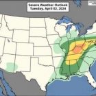
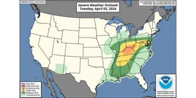
The majority of the state will be under a Level 1 risk that was placed from the Storm Prediction Center—except for a Level 2 risk that is clipping northeast Mississippi. Our main risk for any severe storms will be during the day on Tuesday, with scattered activity becoming more widespread early Tuesday evening. Rainfall total amounts could reach up to three quarters of an inch, with the chance of precipitation being 80%. The high will be near 82, with winds blowing from south to southwest at 10 to 15 mph and gusting up to 25 mph. For Tuesday night, scattered storm activity is possible but otherwise partly cloudy, with a low around 49. Winds will be shifting from the southwest to northwest, blowing at 10 mph, bringing in the cooler temperatures for the rest of the week.
The storms will clear out for Wednesday and make room for plenty of sunshine for us to enjoy. Usually it would be a sauna when the sun comes out after the rain, but this is a different story since the humidity will be lowering and the temperatures will be dropping down below average, with the high being near 63. Winds will be blowing from the west to northwest with wind speeds reaching 10 to 15 mph. For Wednesday night, there will be mostly clear conditions, with a low of 41 and wind speeds decreasing to 5 to 10 mph.
Thursday, we will see another day of temperatures being below average, with the high being near 63 again. It is still going to be very pleasant outside, with clear skies making way for plenty of sunshine. Winds will be coming from the west-northwest around 10 mph. The low for Thursday night will be near freezing, which could lead to frost forming early Friday morning, with temperatures being around 37 overnight. Winds will be coming from the north at 5 to 10 mph.
Expect to wake up to areas of frost early Friday morning. Then, we will remain dry and cool for the entire day, with the sun beaming down on us but not doing too much to warm up the temperatures since it will still remain below average, with the high being near 66. Winds will be coming from the west-northwest, blowing at around 10 mph. Friday night will be mostly clear, with the low being around 39.
Weekend Outlook
This weekend we will see temperatures slowly returning back into the average for this month. Saturday we will have a high near 70, and on Sunday our high will be in the mid-70s. With clear and sunny skies dominating both of these days, there shouldn’t be anything weather-related that would hinder any outdoor activities. Winds will be calm for both of these days, so don’t expect any gusty winds to knock you down. The low for Saturday will be around 43, and the low for Sunday will be about 10 degrees warmer at 53. We will be clear of any rain chances both of these nights, with the weather conditions being clear.
Besides the muggy start on Monday and the rain chances on Tuesday, this week will be very pleasant for any outdoor activity as long as you take into consideration the high wind speeds that will be going on throughout the weekdays. The weekend will be very enjoyable as those high wind speeds will finally have died out by then and will become calm. Stretching just a little bit past the seven day forecast, the solar eclipse will be occurring on April 8, and the weather conditions appear to be mostly sunny, meaning that we won’t be in the dark and miss out on seeing this phenomenon.
Kevion McGee, Student Meteorologist