Apr 9, 2024
TODAY & TONIGHT: We had a wet morning, and unfortunately the rest of our Tuesday is looking to be gloomy and dreary, with more rain on the way. We could potentially see a break in the rain during the evening hours, but the rain will pick back up late tonight and through the overnight hours. Some of this rain could be heavy at times and even could produce flooding in some communities. Because of this, the National Weather Service in Jackson placed northeastern Mississippi counties under a flood watch that will last through Wednesday at 7:00 p.m. Between now and Wednesday evening, total rain amounts are looking to be between 2 to 5 inches. Make sure to grab your umbrella! Severe storms are not expected for the rest of the afternoon and tonight but heavy rainfall is in the forecast. Temperatures will warm into the upper 60s and lower 70s due to the cloud coverage, and it could be a bit breezy at times, with winds out of the southeast at 10 to 15 mph and gusts up to 20 mph. By Tuesday night, temperatures will fall into the lower 60s, with rain lasting through the night.
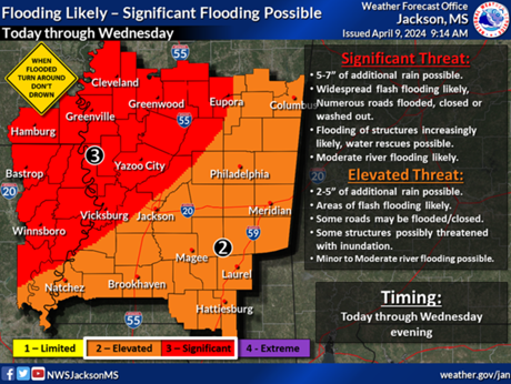
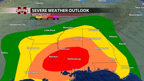
WEDNESDAY: Wednesday will be the most active day of the week, with persistent rainfall that could lead to flash flooding, as well as storms that could potentially be severe. The Storm Prediction Center has outlined most of our viewing area in an enhanced risk, a level 3 out of 5 for severe weather. Stronger severe storms could be possible towards the I-20 corridor and south in central and southern Mississippi, as they have been placed in the moderate risk, a level 4 out of 5. For us here in northeast Mississippi, all modes of severe weather are possible including damaging winds up to 70 mph, hail up to golf ball size, and tornadoes. Timing for the event looks to be through the afternoon and into the evening hours as the surface low tracks east. Make sure to have a reliable way to receive warnings! Temperatures will remain in the low 70s during the day and cool down into the upper 50s at night.
REST OF WEEK AND INTO THE WEEKEND: As the system moves east, so does the rain. There may be a few scattered showers and thunderstorms left over during the day Thursday, but those should clear out by the evening hours. Temperatures will be in the upper 60s during the day and cool off into the upper 40s at night thanks to a passing cold front. Surface high pressure will begin to move in Thursday night, causing us to dry out for Friday and the weekend. Warmer weather returns with highs in the upper 70s and low 80s on Saturday and Sunday.
Belle Oliver
Student Meteorologist