Feb 29, 2024
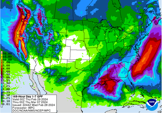
Predicted rainfall totals over the next 7 days. Starkville, Mississippi could receive 1.25-1.75 inches of rainfall from Thursday-Wednesday. (February 29-March 6)
REMAINDER OF TODAY:
Temperatures have shifted to the cooler side since the start of the week. After starting the workweek with warmer temperatures, we are in the low 50s due to a strong cold front passing through yesterday, putting us well below the average high of 63. We are about ten degrees below that number with our Thursday high only hitting 54. Additionally, northeast winds gusting up to 20 mph are making it feel cooler than the low 50s.
TONIGHT AND TOMORROW:
The Golden Triangle area will continue to have cooler temperatures into the overnight hours, with a low of 43. A chance of rain is expected after midnight but predicted rainfall totals are only expected to accumulate to about a tenth of an inch for this round. However, Friday presents itself to be a rather wet day because of a low-pressure trough, bringing with it a decent amount of moisture. As a result, the chance of rain is 90%, along with some embedded thunderstorms being possible. High temperatures on Friday will top out in the mid-50s, with a low in the upper 40s.
WEEKEND AHEAD:
Thanks to dominating southerly winds, expect the first weekend of March to have warm days and comfortable nights. Temperatures during the day are expected to reach the 70s before dropping down to the 50s at night. Saturday will be our best day to be outside as we have minimal rain chances and mostly sunny skies. However, we will have some rain to deal with as we close out our weekend on Sunday, with the best chance of rain beginning in the afternoon hours. That rain will be widespread throughout all of Sunday afternoon, so be sure to keep an umbrella handy if you are going out for any activities.
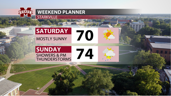
Weekend planner for this weekend in Starkville, Mississippi. Saturday looks to be the better day, with Sunday having showers and storms.
WET PATTERN CONTINUES: WORKWEEK
The beginning of next week starts relatively dreary, with those showers sticking with us through the early morning hours of Monday. You may even hear a few rumbles of thunder as some thunderstorms could be included in that round of showers. A cold front is expected to pass through late Monday night into Tuesday morning, bringing us some more chances of wet weather. This cold front will allow for the continuation of wet conditions and an unstable weather pattern into Wednesday. It would be smart to have your umbrella and rain jacket handy throughout the duration of those days. Temperatures should be relatively comfortable, though, with highs in the upper 60s and lows in the upper 40s on Tuesday and Wednesday.
Student Meteorologist, Nic Temple