Feb 19, 2024
High temperatures this week are going to reach the mid-60s and lower 70s. Warmer air is coming in from the south and will increase our temperatures for the week ahead.
WORK WEEK AHEAD
Tonight, it will be mostly clear with a calm wind. Temperatures will drop quickly into the overnight hours. Clear skies will let the heat escape after sundown.
The temperature will drop near freezing in the Golden Triangle, 35° in Jackson and 42° in Gulfport tonight. Most of northeast Mississippi will be experiencing low- to mid-30s during the overnight hours. These temperatures will be just below the average low for this time of year.
Temperatures will begin to rise this week, so take advantage of it and enjoy the warm sun. Tuesday will be very comfortable reaching 65° in Starkville and the upper 60s just to the south in Jackson.
Don’t forget your blanket on Tuesday and Wednesday during the late afternoon if you plan on attending the Mississippi State’s baseball games against Austin Peay. Temperatures will start pleasant and drop to 39° as the sun goes down on Tuesday night. Spring-like temperatures will continue to rise into Wednesday reaching 73° in the Golden Triangle. It will be mostly sunny along with a nice breeze and a low of 55° in Starkville into Thursday.
Thursday, there is a possibility of some scattered showers after noon. Along with these showers, there will be winds—mostly in the 10-15 mph range—along with some 35 mph gusts. A higher likelihood of scattered showers and thunderstorms will be Thursday night going into Friday morning. Thursday’s low will be around 47° with winds around 10-15 mph and some gusts around 25 mph.
WEEKEND OUTLOOK
Friday, a high-pressure system will move in and push out the rain chances for the weekend. Friday will be a little cooler than the beginning of the week with sunny skies, a breeze including 20 mph gusts, and a high of 66°. Friday night, the sky will be mostly clear with a low of 40°.
Saturday and Sunday will turn out to be perfect days to head outside and enjoy the sun. Saturday’s high will be near 69° with a mostly sunny sky, clouds clearing out by the overnight hours, and a low of 42°. Sunday’s temperatures will be nice with plenty of sunshine, reaching 72° with sunny skies and a low of 50°. These lows are mild for this time of year.
LONG TERM
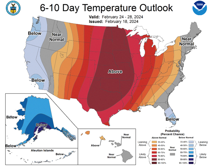
After the high-pressure system builds in on Friday, northeast Mississippi will likely remain above average in temperature for the 6-10 days after this week, as shown by the graphic below from the Climate Prediction Center. The average for this time of year is in the low-60s, and there is a good chance our area will stay above that mark in the foreseeable future, possibly until the start of March.
Northeast Mississippi will continue the warming trend into the end of the month.