Mississippi State University Weather

Scattered Showers Today, Clearing Out Mid-Week

Scattered Showers Today, Clearing Out Mid-Week

Feb 12, 2024

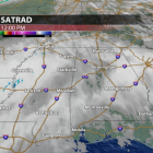
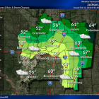
Overcast and dreary to start off the next work week! Heavy cloud coverage will stick around for the remainder of the day. Scattered showers and a few storms are likely through the day as an area of low pressure makes its way across northern Mississippi. It will be slightly cooler today with temperatures ranging from the mid 50s to low 60s across the region this afternoon. Winds will quickly begin to pick up as we head into the afternoon and evening hours, so expect a breezy evening. Wind gusts could possibly exceed 20-25 mph at times. Heading into the overnight hours, clouds will linger until just after midnight tonight. We’ll see a drop in temperatures starting tonight with overnight lows in the middle to upper 30s. Drier days ahead! As the showers and storms clear out of the area by early Tuesday, high pressure builds into the region to give us much nicer weather for the next few days. Cooler conditions are expected for our Tuesday with highs only reaching the mid 50s for the afternoon. Chilly mornings continue through Thursday with morning temperatures in the mid 30s. Temperatures return to the 60s for the next few days with plenty of sunshine, so pleasant conditions for any outdoor plans you have! Looking ahead to the end of the work week, we have our next system making its way into northern Mississippi. A southwesterly flow allows for more moisture and instability which will help to increase rain chances for Friday and Saturday. There will be a steady increase in cloud coverage throughout the day on our Friday that will bring additional showers for Friday night into Saturday. As of right now, rain totals do not look as impressive as this past weekend’s. Things will dry out by Sunday to give us mostly sunny skies and a pleasant afternoon. Colder air is expected to move in for Saturday evening and Sunday, so be prepared for a chilly start as you step out the door Sunday morning. Temperatures will be more seasonal heading into the beginning of the next work week with highs in the mid 50s and lows in the upper 20s to mid 30s. Campus...

Wet Weekend Ahead Brings More Seasonal Temperatures

Wet Weekend Ahead Brings More Seasonal Temperatures

Feb 8, 2024

Hope everyone is having a great week! The weather sure has been wonderful these past few days with sunshine and warm temperatures well into the 60s. As of Thursday afternoon, satellite and radar shows high clouds building into northeast Mississippi ahead of our next storm system. It’s also a bit breezy as winds are now gusting up to 20 mph from the south which will aid in transporting plenty of moisture our way. Tonight, we’ll remain dry with temperatures remaining warm in the mid-upper 50s with a few scattered rain showers developing. These will continue into our Friday and become more frequent throughout the late morning and early afternoon. Amidst the rain and clouds, temperatures will still manage to near the 70° mark on Friday with noticeably more muggy conditions in place as well.  The weekend ahead looks nasty in terms of any outdoors plans. As a stationary front stalls to our north, several waves of energy will ride along it, each bringing another chance for rain between Friday and Monday. However, it will not be raining the entire time and there are no threats for any flooding. The most notable and perhaps consistent period of rain looks to arrive on Saturday afternoon, lasting into Sunday morning as heavier rain develops to our southwest and rides along that front into northeast Mississippi. Most of Saturday morning and Sunday afternoon appear to be dry with only a few scattered rain showers passing through. The GFS Future-cast model below shows these repeated rounds of showers and periodic steady rain. The good news is temperatures will continue to remain above average in the upper 60s which is much better than a cold rain! Moving into our next work week, the stationary front bringing us the weekend rain will eventually pass through as a cold front late Sunday night and early Monday, providing another chance for widespread rain and likely tallying up our total weekend rainfall to 1-2”. This front will also swing in some cooler temperatures with highs back in the upper 50s and lows in the lower 30s next Monday through Wednesday. Although this may seem chilly, we will be back near our average and exactly...

Warm and Quiet End To The Week! 

Warm and Quiet End To The Week! 

Feb 2, 2024

This warm and quiet week has come as a welcomed break following two weeks of active weather across the region. Our warmth peaked on Tuesday when highs exceeded 70°! Since then, a cold front has dropped temperatures into the 50s, but we will warm back into the 60s Friday and Saturday. Our dry streak ends on Sunday when a system brings rain back into the area.  Back Into The 60s On Friday The high clouds that have been around for much of Thursday will clear slightly overnight. Temperatures will fall to around 40° Friday morning. This is roughly 10° warmer than the previous mornings this week, but you’ll still need a jacket to start the day! We will end the work week with another warm day. Highs will be roughly 10° above average on Friday as we climb into the mid-60s under mostly sunny skies.  The Weekend Starts Nice Before Rain Returns Above average temperatures continue to start off the weekend. Saturday will start chilly with temperatures in the low-40s, but by the afternoon the mid-60s are back! Be sure to take advantage of the dry, spring- like weather because rain moves in before sunrise on Sunday. The high pressure that has kept us dry for much of the week will give way to a system that will pass to our south. Rain will persist for much of the day and could exceed an inch in spots. Generally, 0.75”-1.25” will be a safe bet. Due to the wet weather, Sunday will be cooler with highs in the mid-50s.  Seasonable Next Week  The most consistent rain should be out of the area by Monday, but lingering showers will remain possible, especially in the morning. Otherwise, most of next week looks dry! Temperatures will be seasonable with highs in the mid-50s and lows in the low to mid-30s. The next chance for rain does not look to arrive until the end of the week.  Drought Update  Following the repeated rounds of rain last week that brought a deluge to our area, a big dent was made in Mississippi’s drought! A new drought monitor was released today (2/1) and reflects the heavy rain we received. It is...

Mild Workweek Ahead with Sunshine and Near Seasonable Temperatures

Sunny and calm conditions for the next several days Monday afternoon saw mostly sunny skies as cloud cover from earlier in the day moved eastward. This will continue into the overnight hours as we see partly cloudy skies and calm winds for the evening. The calm conditions are caused by high pressure building into the area behind last Saturday’s low pressure system. High pressure is expected to control our forecast for the next several days, making this week a great time to plan any outdoor activities. Any remaining cloud cover from overnight will move out by Tuesday morning as we see clear blue skies throughout the day tomorrow. We will continue to see lots of sunshine as we finish out the month of January this Wednesday. The first two days of February will be similar, with mostly clear skies sticking around until Friday evening when, cloud cover starts to increase ahead of our next chance for rain this weekend. Another low pressure system is expected to arrive between Saturday and Sunday evening, bringing a chance for showers and thunderstorms. Up and down temperatures Along with calm conditions, Monday also had below average temperatures. The afternoon high peaked in the mid to upper 40s where it would typically be in the mid 50s. This is because of the aforementioned weekend low pressure system and subsequent cold front on Saturday night. This will change as high pressure is returning to the area. Overnight temperatures will be average with lows dipping into the lower 30s for the start of Tuesday morning, but this will change a lot by Tuesday afternoon. Temperatures are expected to peak in the mid 60s tomorrow which is 10 degrees above average. That also means that we will warm by more than 30 degrees from morning to afternoon, so dressing with removable layers is recommended. Tomorrow evening will continue to see temperatures slightly above average as they will only drop into the upper 30s. A dry cold front will swing across the area Tuesday night, briefly bringing temperatures back to normal on Wednesday. Afternoon highs will be in the lower 50s with lows back in the low 30s, giving us a very reasonable...