Check weekly for the latest forecast from the broadcast meteorology practicum students!
Seasonable Weekend Ahead
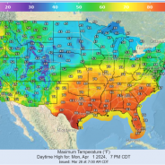
This morning, we started the day with partly sunny skies. Temperatures are expected to make it to 80 degrees today. This is all thanks to a high-pressure system that is to our south, moving east towards Georgia and the Carolinas. There is a small chance that we will see some showers and thunderstorms along and North of highway 82 this afternoon thanks to a stationary front that has stalled over parts of northern Mississippi. The chance for showers and storms will quickly end in the evening hours as the front moves north. Tonight, it will be partly cloudy with temperatures in the upper 50s to lower 60s for the region. WARMER TEMPERATURES FOR THE WEEKEND This weekend will be beautiful for any outdoor activities that you may have planned, as it will be mostly sunny with a few clouds possible. There may be a chance of a shower or two this weekend in some areas, but confidence is not high. Temperatures are expected to be above average in the lower to mid 80s. This is due to a warm front that moved through the area, which is bringing in warmer temperatures from the Gulf of Mexico and high-pressure system that is still in place. This will also cause strong winds coming out of the South which will lead to winds being around 5-15 MPH with wind gusts anywhere up to 25-30 MPH for the entire weekend. NEXT WEEK After the dry week that we have had, rain chances are coming back into the forecast for late Sunday night into Monday morning. Warm, moist air due to high pressure that is still in place over the region, will set us up for a disturbance that will move into the area ahead of a cold front. Rain amounts are expected to be heavy due to the amount of moisture that will be available in our atmosphere, and we can expect anywhere from 0.5 to 1 inch of rain from this event. Tuesday morning there is a chance that there will be a lingering shower or two, but not much rain is expected. Looking past Tuesday, high-pressure will move into place over the Mississippi Valley region, which will allow for the warmer conditions to continue with temperatures pushing towards the 90-degree...
read moreGreat Weather Ahead for Mississippi This Week!
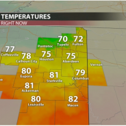
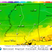
Temperatures on Sunday at 1 pm As we go into the workweek, expect overall dry conditions and gradually warming temperatures from the upper 60s Monday, all the way into the mid-80s by Sunday! The best chances of rain to come this week are on Wednesday and Thursday. Monday-Tuesday: A high pressure system will move on through Mississippi throughout Monday and Tuesday bringing in cool and dry northerly winds into our region. Expect sunny conditions Monday, with highs to reach the mid-60s and lows to be in the low 40s, with both of these temperatures being roughly 10 degrees cooler than the average for mid-to-late April! For Tuesday, expect much of the same story in terms of being dry and nice outside, but there will be a nice bump up in temperatures thanks to the absence of the high pressure system moving on into the east coast. This will introduce warmer and more humid southerly winds into our region. Overall, it will still be comfortable, with sunny conditions. We will have highs in the mid-70s and lows in the mid-50s. Expected temperatures on Tuesday at 3 pm Wednesday-Thursday: Wednesday and Thursday will be the two days to consider for any potential showers or storms. On Wednesday, a weak surface front will pass along our region throughout the day that could cause a shower or two. Overall, we don’t see the frontal system being strong enough to create many, if any, storms, so expect mainly sunny conditions, with highs in the upper 70s and lows in the upper 50s. Thursday will probably have the best chance of rain this week, as a stronger short wave will enter our region, causing a greater chance of showers and isolated t-storms throughout the morning and mid-afternoon hours. Expect a 30% chance of isolated t-storms, with highs in the upper 70’s and mostly cloudy conditions at night, with lows in the mid-50s. Thursday rain outlook at 1 pm Friday-Sunday: If you are looking for a nicer weekend compared to what we had last week, you got it! Ridging will build in our viewing area starting Friday and continue to strengthen into the weekend, which will bring in much warmer and drier conditions. Expect very nice weather with partly cloudy skies and temperatures being above average, with highs starting out in the upper 70s Friday and increasing into the low 80s throughout Saturday and Sunday. Recap: Overall, a great week if you have anything planned outdoors. Just keep an eye out on Wednesday and Thursday for any stray showers or t-storms that may affect the viewing area. Have a great week! Michael Sokell Student...
read moreWarm Temperatures, Storms Likely For Super Bulldog Weekend
If you haven’t been a fan of the above normal temperatures, you’re in luck. Some relief is on the way but, you will just have to wait a few more days. Temperatures will continue to be above normal until this weekend, as highs will dip into the upper 50s for Sunday. These will be below average for this time of the year. TODAY AND TONIGHT Spotty showers are still expected during the late afternoon hours. It won’t be a total washout as you’re heading home for your evening commute or sporting activities. Tonight, a cold front moves into the region giving way to some thunderstorms. Lows tonight will dip into the upper 50s. These storms do have the potential to be severe, as the Storm Prediction Center has a marginal risk put out for the area. Damaging winds and heavy rain are the main threats. SUPER BULLDOG WEEKEND The 3-game series between Mississippi State and Auburn baseball is expected to begin at 6pm on Friday. First pitch, you can expect mostly cloudy skies. So, a light sweater might be suitable as the winds may cause the temps to feel a degree or two colder. Low temperatures will reach the 60s with a north wind at 5 mph. Saturday into Sunday, rain percentages will range from 50-70%, so be sure to bring an umbrella or jacket as you’re heading out to any of the sporting events. After these rounds of showers and thunderstorms over the weekend, a high pressure will gradually begin to slide into the region Sunday. This is bringing dry conditions and cool temperatures into Monday with lows being in the 40s. Temperatures begin to warm back up to near and above average early next...
read moreClouds Return Monday and for the Rest of the Week after a “Picture Perfect” Weekend
After a divine weather weekend, clouds will return on Monday and remain throughout the week. With temperatures remaining warm in the low- to mid-80s, a temperature drop is expected on Sunday. There is a slight chance of showers Tuesday night, which will linger through the rest of the workweek and into the weekend. By Thursday and Friday, we will see rain chances persist throughout the day. So, if you’re planning on attending either some Bulldog or Yellow Jacket baseball, it wouldn’t be a bad idea to come prepared with some rain gear, just in case. With that being said, the chance of showers will begin to increase throughout the weekend as a cold front passes through on Saturday. Today into Tomorrow Night We are having a beautiful Monday to begin the workweek, as temperatures sit around the low 80s. A light wind blowing at 6-8 mph from the south will continue throughout the day and into the night. Temperatures will cool off into the low 60s Monday night, and cloud cover will build up and remain throughout the night and into Tuesday, making Tuesday a rather cloudy day. Temperatures will peak in the low 80s again on Tuesday, but winds will blow southerly, and vary from 6-16 mph, with gusts reaching 25 mph, as showers move into our area. By late Tuesday night, a chance of rain is expected. Slight Rain Chances Persist Throughout the Week These southerly winds are also blowing moisture in from the Gulf of Mexico, effectively raising our dew point temperatures, thus making it a quite humid week. We will see a chance of rain is expected after 2 pm come Thursday. Come Friday, if you’ve made plans to go out and about in the morning, or you’re just walking to class, prepare for some showers. Temperatures will remain in the 80s throughout the week until Saturday night, where a cold front will then blow through, cooling us down, and allowing us to see temperatures drop to the upper 60s. This will give the Bulldogs a rather cooler day at the Dude to wrap up the series against Auburn. Keep in mind, a chance of rain persists through Sunday. To Wrap Things Up This week will ultimately be quite calm and pretty. Rain chances will begin in the middle of the workweek and persist till the end of the weekend. Other than a cold front moving in Saturday night and dropping Sunday’s temperatures to the high 60s, nothing too drastic is set to move through Starkville. Although umbrellas may be necessary at times, conditions will be quite nice. Emmett Rice, Student...
read moreSoggy and Windy Thursday, But Sunny Weekend Ahead!
TODAY AND TONIGHT After a rather rainy and stormy beginning to our workweek, we finally are seeing the light at the end of the tunnel! Northeast Mississippi has seen lots of rain over the past 24 hours, with the bulk of the rain totals in the western portion of our viewing area. Grenada and northern parts of Winona received over 7.5 inches of rain! Starkville received just over 2.5 inches of rain, and this is on top of what we already received Monday and Tuesday! Although we are out of the flood watch, it is important to remember the saying, “turn around, don’t drown”, when approaching flooded roads. A cold front will pass through during the afternoon hours, which will push any leftover rain showers out to our southeast. As the front passes, wind gusts will start to pick up, gusting over 30 mph throughout our viewing area. During the later part of the afternoon, we could see some of the greatly missed sunshine peep through those clouds! This will be a great time to take those furry friends on a walk but be sure to grab a light jacket. Due to the passing front, temperatures will have a steady drop as we go into the nighttime hours, hitting the lower 60s by 6pm. Our overnight low will be in the mid to upper 40s, with clear skies and calming wind gusts. TOMORROW Due to a high-pressure system that will be coming from the west and stationing over parts of East Texas, Western Louisiana and along the gulf, we will start to see sunshine come into the forecast once again! High temperatures will hit 70°, with very limited cloud cover, if any at all. Overnight lows will once again drop into the mid 40s, due to clear skies and no cloud coverage being able to trap in the warmer air. THE WEEKEND It will be all sunshine and rainbows for the weekend with temperatures increasing each day! High temperatures will near 80° on Saturday with partly cloudy skies. Sunday is when we will hit the lower 80s making it a nice day to sit out at the pool. EARLY NEXT WEEK Temperatures will continue to increase into the mid 80s, which is about 10° higher than our average temperatures for mid-April. We will keep those partly cloudy skies into Wednesday, where rain chances climb back to 20%.Laine PughStudent...
read moreSoggy Tuesday, with more rain and possible severe storms on the way
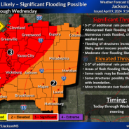
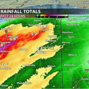
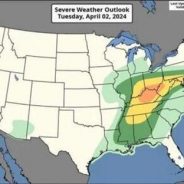
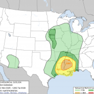
TODAY & TONIGHT: We had a wet morning, and unfortunately the rest of our Tuesday is looking to be gloomy and dreary, with more rain on the way. We could potentially see a break in the rain during the evening hours, but the rain will pick back up late tonight and through the overnight hours. Some of this rain could be heavy at times and even could produce flooding in some communities. Because of this, the National Weather Service in Jackson placed northeastern Mississippi counties under a flood watch that will last through Wednesday at 7:00 p.m. Between now and Wednesday evening, total rain amounts are looking to be between 2 to 5 inches. Make sure to grab your umbrella! Severe storms are not expected for the rest of the afternoon and tonight but heavy rainfall is in the forecast. Temperatures will warm into the upper 60s and lower 70s due to the cloud coverage, and it could be a bit breezy at times, with winds out of the southeast at 10 to 15 mph and gusts up to 20 mph. By Tuesday night, temperatures will fall into the lower 60s, with rain lasting through the night. WEDNESDAY: Wednesday will be the most active day of the week, with persistent rainfall that could lead to flash flooding, as well as storms that could potentially be severe. The Storm Prediction Center has outlined most of our viewing area in an enhanced risk, a level 3 out of 5 for severe weather. Stronger severe storms could be possible towards the I-20 corridor and south in central and southern Mississippi, as they have been placed in the moderate risk, a level 4 out of 5. For us here in northeast Mississippi, all modes of severe weather are possible including damaging winds up to 70 mph, hail up to golf ball size, and tornadoes. Timing for the event looks to be through the afternoon and into the evening hours as the surface low tracks east. Make sure to have a reliable way to receive warnings! Temperatures will remain in the low 70s during the day and cool down into the upper 50s at night. REST OF WEEK AND INTO THE WEEKEND: As the system moves east, so does the rain. There may be a few scattered showers and thunderstorms left over during the day Thursday, but those should clear out by the evening hours. Temperatures will be in the upper 60s during the day and cool off into the upper 40s at night thanks to a passing cold front. Surface high pressure will begin to move in Thursday night, causing us to dry out for Friday and the weekend. Warmer weather returns with highs in the upper 70s and low 80s on Saturday and Sunday. Belle Oliver Student...
read moreQuiet Now, But Storms on the Way
TODAY AND TONIGHT We had a much cooler start to the day with a low in the 40s but warmed up to a more seasonable temperature hitting the mid 60s. The rest of the day will be sunny and mostly pleasant, except for some wind gusts that could reach up to 25 mph. Dry weather and gusty winds creates a limited fire weather risk for some portions of our viewing area, so be cautious of open burning this afternoon. Winds will calm through the overnight hours and there will be a significant cooldown to the upper 30s. Clear night skies will keep the temperature cooler. CALM START TO THE WEEKEND Calm conditions are to be expected Friday through Saturday as a high-pressure system moves eastward through Northeast Mississippi. There will be plenty of sunshine on Friday, with warmer temperatures reaching the upper 60s. However, it will again be a chilly night in the low 40s. A warming trend will continue Saturday, reaching a high of 70. Much like Friday night, Saturday evening will still be cool, but low temperatures will be closer to the 50s. Calm conditions will persist through the night and the start of Sunday. Temperatures will warm up even more on Sunday, reaching the upper 70s. RAIN CHANCES INCREASING INTO THE WEEK Sunday will begin mostly sunny, but slight chances of rain will grow through the day as a low-pressure system approaches the Southeast. The main threat is scattered showers and thunderstorms that will begin after 1pm and will increase into the evening as cloud coverage builds. Scattered thunderstorms are likely through the night, and could be accompanied by some gusty winds of up to 25 mph. The low-pressure system will shift north at the start of the week, but a cold front will stall over the area and rain chances will continue to increase through Tuesday night, likely sticking around through Thursday. Precipitation chances on Monday are around 30%, but this will increase to 50% on Tuesday and Wednesday. The arrival of the cold front will drop temperatures a few degrees, but it will still be quite seasonable with highs in the mid 70s and lows in the 60s Monday through Wednesday. FLASH FLOODS AND SEVERE STORMS POSSIBLE The active weather will bring a threat of flash flooding as there could be multiple rounds of heavy rain embedded within the system as it stalls over our viewing area for a few days. There is also a potential threat of severe weather to our west for Monday into midweek, so it is important to stay weather aware throughout the upcoming active days as the forecast updates. Ashlyn MooreStudent...
read moreToo Hot! Too Cold! Just Right!
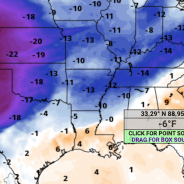
We’re seeing a cloudy and humid day to kick off this week, with winds coming from the southwest blowing at 10 to 15 mph throughout the course of Monday. After a week of seasonal temperatures and dry conditions, temperatures will soon be dropping below average. However, for Monday’s forecast, temperatures will be very warm, with the high reaching in the mid-80s. Monday night, temperatures will be dropping to a more pleasant condition, with the low being in the upper-60s, as the cloud cover will maintain some of the heat that we experience throughout the day. Windy conditions will be expected, as winds could gust as high as 25 mph. The majority of the state will be under a Level 1 risk that was placed from the Storm Prediction Center—except for a Level 2 risk that is clipping northeast Mississippi. Our main risk for any severe storms will be during the day on Tuesday, with scattered activity becoming more widespread early Tuesday evening. Rainfall total amounts could reach up to three quarters of an inch, with the chance of precipitation being 80%. The high will be near 82, with winds blowing from south to southwest at 10 to 15 mph and gusting up to 25 mph. For Tuesday night, scattered storm activity is possible but otherwise partly cloudy, with a low around 49. Winds will be shifting from the southwest to northwest, blowing at 10 mph, bringing in the cooler temperatures for the rest of the week. The storms will clear out for Wednesday and make room for plenty of sunshine for us to enjoy. Usually it would be a sauna when the sun comes out after the rain, but this is a different story since the humidity will be lowering and the temperatures will be dropping down below average, with the high being near 63. Winds will be blowing from the west to northwest with wind speeds reaching 10 to 15 mph. For Wednesday night, there will be mostly clear conditions, with a low of 41 and wind speeds decreasing to 5 to 10 mph. Thursday, we will see another day of temperatures being below average, with the high being near 63 again. It is still going to be very pleasant outside, with clear skies making way for plenty of sunshine. Winds will be coming from the west-northwest around 10 mph. The low for Thursday night will be near freezing, which could lead to frost forming early Friday morning, with temperatures being around 37 overnight. Winds will be coming from the north at 5 to 10 mph. Expect to wake up to areas of frost early Friday morning. Then, we will remain dry and cool for the entire day, with the sun beaming down on us but not doing too much to warm up the temperatures since it will still remain below average, with the high being near 66. Winds will be coming from the west-northwest, blowing at around 10 mph. Friday night will be mostly clear, with the low being around 39. Weekend Outlook This weekend we will see temperatures slowly returning back into the average for this month. Saturday we will have a high near 70, and on Sunday our high will be in the mid-70s. With clear and sunny skies dominating both of these days, there...
read moreBeautiful Easter Weekend Ahead
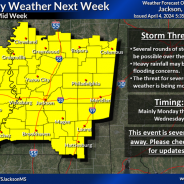
Today we woke up to clear skies and seasonably cooler temperatures. Following these cooler temperatures is a warming trend. A high-pressure system is helping to keep the weather in our region quiet. The temperature will reach the upper 60s today with the wind coming from the north at 5-10 mph. The sky conditions will remain sunny without a cloud in the sky. This weather will persist for the rest of the week and into the weekend. As sunset approaches today, the sky will remain clear and the temperatures will reach a low in the upper 30s with calm winds. TEMPERATURES ON THE RISE As the week continues warm air advection is causing the temperatures to rise day-by-day. Friday is expected to be sunny and clear with the temperatures topping out in the lower 70’s. The sunset will bring about a possibility for some clouds to roll into the area. As the weekend nears, we are likely to experience temperatures in the 80s with sunny skies. Temperatures on Easter Sunday are projected to reach into the lower 80s at the peak of the day. Expect gusty conditions this weekend with winds coming from the south-southwest at 5-10mph with the possibility for gusts up to 20 mph. As the workweek begins, we should see partly sunny skies with temperatures in the mid- 80s. Monday is going to be the hottest day that we experience in the next week even though it will be mostly cloudy. THE NEXT RAINMAKER Early Tuesday morning comes the next possibility of rain. Showers and some storms are possible early Tuesday morning. With the warm weather and instability that has built up before the rainmaker, the chance of thunderstorms is enhanced. Specific details about the possibility of shear and instability of the atmosphere cannot be determined quite yet since the system is still a couple of days out. The main threats we’re watching right now are damaging straight line and flooding concerns. Severe weather can not be ruled out quite yet. Following the wet weather, we are expecting to see cooler than normal temperatures return to our area. LOOKING TOWARD THE FUTURE Despite the arrival of cooler temperatures after the rain system moving through Tuesday, the region is expected to have above average temperatures. These temperatures will be accompanied by more rain chances. Ashtyn LedouxStudent...
read moreA Stormy Start to the Week, Clear Conditions By Midweek
Today has been for the most part quiet and breezy, however rain and storms are starting to approach and move into the region surrounding Starkville, Mississippi quickly. The rain and storms are associated with a low pressure system that is approaching the area. This system will move through during the evening/night hours into the early morning hours tomorrow, bringing rain and storms with some being severe. Rain and storms will clear out by tomorrow afternoon, making way for sunny and clear conditions that will persist through the weekend and into next week. A STORMY START TO THE WEEK TONIGHT INTO TOMORROW AFTERNOON While temperatures have been sitting in the low to mid-60s throughout the day, gusty winds out of the southeast have helped to increase moisture ahead of the cold front that is expected to move through. As a result, a wind advisory is in effect. The characteristics of the environment are typical for a common early spring, as there is high shear and low CAPE (Convective Available Potential Energy) across the region. The main concern for Starkville, Mississippi with these storms is damaging winds, isolated tornadoes, sustained winds of 20+mph, and minor flooding. The main line of storms is expected to roll through between 9 PM and 1 AM, however rain before and after this line is likely. Flooding is only expected to occur in low lying areas and areas with poor drainage, and possibly near lakes and rivers around the area. Water levels in these bodies of water have receded since the last rainfall. It is suspected that the main severe impacts will stay just to the west of Starkville, with Starkville being on the fringe of the boundary between the enhanced and slight risk areas. Instead, the Severe Prediction Center elected to keep Starkville under a slight risk. However an isolated severe storm in or around Starkville cannot be ruled out. The main severe weather threat and the heaviest of the rain will end with the passage of the cold front making way for a temporary cool-off and dry weather throughout the area. CLEAR CONDITIONS STARTING TUESDAY NIGHT AND PERSISTING THROUGH THIS WEEKEND High pressure will begin to build behind the cold front that will move through, beginning an extended period of dry conditions to the area. Skies will be clear around the region over the next couple days, with high temperature sitting in the low to mid-60s, and low temperatures sitting in to mid-30s to low 40s through Thursday. The high pressure system will move eastward Thursday into Friday, and with that high temperatures will climb into the 70s, which is a trend that will not change through Sunday. Clouds are expected to return next Sunday and persist throughout the start of the wee. Temperatures are expected to reach into the high 70s to low 80s before rain rolls through next Tuesday, bringing temperatures back into the high 60s or low 70s. Mitchell KeyesStudent...
read more