Check weekly for the latest forecast from the broadcast meteorology practicum students!
Warm and Quiet End To The Week!
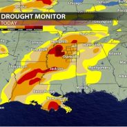
This warm and quiet week has come as a welcomed break following two weeks of active weather across the region. Our warmth peaked on Tuesday when highs exceeded 70°! Since then, a cold front has dropped temperatures into the 50s, but we will warm back into the 60s Friday and Saturday. Our dry streak ends on Sunday when a system brings rain back into the area. Back Into The 60s On Friday The high clouds that have been around for much of Thursday will clear slightly overnight. Temperatures will fall to around 40° Friday morning. This is roughly 10° warmer than the previous mornings this week, but you’ll still need a jacket to start the day! We will end the work week with another warm day. Highs will be roughly 10° above average on Friday as we climb into the mid-60s under mostly sunny skies. The Weekend Starts Nice Before Rain Returns Above average temperatures continue to start off the weekend. Saturday will start chilly with temperatures in the low-40s, but by the afternoon the mid-60s are back! Be sure to take advantage of the dry, spring- like weather because rain moves in before sunrise on Sunday. The high pressure that has kept us dry for much of the week will give way to a system that will pass to our south. Rain will persist for much of the day and could exceed an inch in spots. Generally, 0.75”-1.25” will be a safe bet. Due to the wet weather, Sunday will be cooler with highs in the mid-50s. Seasonable Next Week The most consistent rain should be out of the area by Monday, but lingering showers will remain possible, especially in the morning. Otherwise, most of next week looks dry! Temperatures will be seasonable with highs in the mid-50s and lows in the low to mid-30s. The next chance for rain does not look to arrive until the end of the week. Drought Update Following the repeated rounds of rain last week that brought a deluge to our area, a big dent was made in Mississippi’s drought! A new drought monitor was released today (2/1) and reflects the heavy rain we received. It is a great improvement from the previous drought map, but the highest level of drought is still present along I-55 in northern Mississippi. Hopefully the El Nino pattern we are currently in will continue to bring us wet weather that can chip away at our rainfall deficits! Owen BasselmanStudent...
read moreMild Workweek Ahead with Sunshine and Near Seasonable Temperatures
Sunny and calm conditions for the next several days Monday afternoon saw mostly sunny skies as cloud cover from earlier in the day moved eastward. This will continue into the overnight hours as we see partly cloudy skies and calm winds for the evening. The calm conditions are caused by high pressure building into the area behind last Saturday’s low pressure system. High pressure is expected to control our forecast for the next several days, making this week a great time to plan any outdoor activities. Any remaining cloud cover from overnight will move out by Tuesday morning as we see clear blue skies throughout the day tomorrow. We will continue to see lots of sunshine as we finish out the month of January this Wednesday. The first two days of February will be similar, with mostly clear skies sticking around until Friday evening when, cloud cover starts to increase ahead of our next chance for rain this weekend. Another low pressure system is expected to arrive between Saturday and Sunday evening, bringing a chance for showers and thunderstorms. Up and down temperatures Along with calm conditions, Monday also had below average temperatures. The afternoon high peaked in the mid to upper 40s where it would typically be in the mid 50s. This is because of the aforementioned weekend low pressure system and subsequent cold front on Saturday night. This will change as high pressure is returning to the area. Overnight temperatures will be average with lows dipping into the lower 30s for the start of Tuesday morning, but this will change a lot by Tuesday afternoon. Temperatures are expected to peak in the mid 60s tomorrow which is 10 degrees above average. That also means that we will warm by more than 30 degrees from morning to afternoon, so dressing with removable layers is recommended. Tomorrow evening will continue to see temperatures slightly above average as they will only drop into the upper 30s. A dry cold front will swing across the area Tuesday night, briefly bringing temperatures back to normal on Wednesday. Afternoon highs will be in the lower 50s with lows back in the low 30s, giving us a very reasonable last day of January. Things will quickly warm back up for the start of the new month with Thursday and Friday seeing highs in the upper 50s to mid 60s and lows around 40 degrees. Overall, the mild temperatures coupled with lots of sunshine makes for plenty of chances to enjoy getting outdoors during the week before more active weather conditions arrive on Saturday. Despite the rain, temperatures will remain above average during this time. Annea Scales Student...
read moreAbove Average Temperatures Ahead of Cold Front- Week of October 2nd Forecast
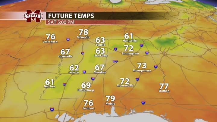
Spooky season has arrived, and high pressure continues to dominate the forecast both tonight and for the next couple of days. This is keeping things warm and dry across Northeast Mississippi. Monday has seen mostly sunny conditions and temperatures in the upper 80s. Tonight, we will cool down into the 70s after sunset. Heading out the door tomorrow, the forecast will be almost a carbon copy of today’s. Temperatures will start out sort of chilly in the upper 50s, but warm by 30 degrees as we head into the afternoon. High temperatures will reach into the upper 80s once again, so if you wear a jacket to your first class, you definitely will not need it by the end of the day. Thankfully, the air is dry enough to keep the heat index down with dewpoints in the 50s throughout this week. Tuesday night will see temperatures drop into the 50s once again, but we will be approaching the lower 90s by Wednesday afternoon as we have another day full of sunshine across the area. Not only are these temperatures several degrees above average for the beginning of October, we will also continue to see drought conditions. Tomorrow will remain dry as well as the next several days. The next chance for rain arrives towards the end of this week as a cold front moves into the area late on Thursday. Ahead of this, we are expecting to see scattered showers and maybe even an isolated thunderstorm ranging from late Thursday to Friday evening. No severe weather is anticipated for this system. Overnight temperatures will remain in the mid 60s during this time. Afterwards, fall-like weather will finally arrive as high pressure builds back in for the weekend. While Thursday and Friday will warm into the lower to mid 80s amidst showers, the weekend will see afternoon highs around 10 degrees cooler than that. We may struggle to reach 70 by Saturday. This is great news for anyone heading out to see Mississippi State play Western Michigan at Davis Wade Stadium this weekend. Kickoff is at 11am, so these cooler temperatures will definitely make the afternoon game a more pleasant experience. Overnight lows will dip down into the 40s, making for cooler than average conditions. People who have been awaiting crisp fall weather should be very excited for the start of next week as it is almost time to unpack those sweaters and enjoy some pumpkin flavored goodies. Event though the first week of October has gotten off to a warm start, cooler weather is on the way. Annea Scales Student Meterologist...
read moreWarm Days, Cool Nights Ahead – Week of September 18th Forecast
Our weather is on cruise control this week! A quiet weather pattern will take over, leaving us high and dry with consecutive sunny days. MONDAY NIGHT: Cool temperatures and calm winds. Patchy fog is possible before sunrise. Temperatures will dip into the mid-50s, so you might want to grab a hoodie or light jacket before leaving for those 8 a.m. classes. TUESDAY: It’ll feel cool and crisp outside again on Tuesday morning with temperatures in the mid and upper 50s! Patchy fog is possible, so keep that in mind on your commute to class. Once the fog lifts, it’s another beautiful day! Warm in the sun, but still comfortable. Temperatures will climb into the mid-80s on Tuesday afternoon. TUESDAY NIGHT: Another cool night! A few passing clouds overhead with lows in the upper 50s. REST OF THE WEEK: Beautiful! A little bit warmer on Wednesday, but upper 80s are the warmest we’ll get this week. Humidity will increase a little bit by mid-week as winds shift out of the south and east, but it won’t be a drastic change. You may not even feel a difference since moisture will still be limited. This will also keep rain chances out of the picture. We aren’t expecting any fronts or systems to impact our weather over the next six or seven days, so things look quiet for the rest of the week. Our next chance for rain won’t come until Sunday or early next week. We’re ok right now, but drought conditions could become an issue in the future, depending on how long this dry spell lasts. We’ll keep you posted! TROPICAL UPDATE: Hurricane Nigel is strengthening in the central Atlantic Ocean and could become a major hurricane by Tuesday. This storm is no threat to land and will curve out to sea later this week. The National Hurricane Center is monitoring two other disturbances in the Atlantic that could become tropical systems sometime over the next week, but neither of them are a threat to the Gulf Coast at this time. Have a great week, and Hail State! Dylan Hudler Student Meteorologist...
read moreA taste of fall arrives on Wednesday! – Week of September 11th Forecast.
We started the week off on a warm note with highs in the low-90s on Monday. We have one more warm day on Tuesday before a taste of fall arrives mid-week and lasts through the weekend. TUESDAY: A cold front will approach from the northwest and will bring the chance for a few showers throughout the day. Because of the rain, high temperatures will be slightly cooler than Monday, topping out in the upper-80s. TUESDAY NIGHT: A couple of showers are possible after sunset. Otherwise, it’ll be cloudy and comfortable with a low in the mid-60s. WEDNESDAY: Mostly cloudy skies with a few lingering showers behind the cold front. High temperatures will back off into the low-80s. THURSDAY: The humidity relief behind the cold front will be noticeable on Thursday. Combined with highs in the low-80s, it will feel great outside! After a couple days with rain chances, we will stay dry with partly cloudy skies. FRIDAY – SUNDAY: Highs will remain in the low-80s allowing our stretch of comfortable weather to continue through the weekend. There is a chance for scattered showers or storms on Saturday. Heads up if you have plans to tailgate or go to the Mississippi State football game. Stay tuned to our social media for updates on the forecast! Owen Basselman Student Meteorologist...
read moreComfortable Temperatures Ahead! – Week of September 4th Forecast
Here is the forecast for...
read more