Check weekly for the latest forecast from the broadcast meteorology practicum students!
Rainy End to the Week, But a Beautiful Weekend Ahead
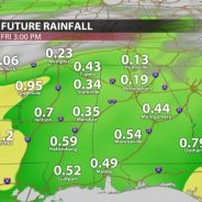
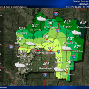
Friday morning, we will see some rain return to northeast Mississippi in the form of showers and possibly some more moderate rainfall. This is expected to move out by the evening. The rain totals will be greater with westward extent, with our area receiving anywhere from 0.25”-0.5” throughout the day. Temperatures to close the workweek will be in the lower 60s across the region, dropping only into the lower 50s at night, as the cloud cover will mediate the temperatures. WEEKEND OUTLOOK This weekend will see temperatures return into the middle 60s on Saturday as we dry out from Friday’s rain, and possibly up to 70 in some areas on Sunday. With clear, sunny skies there should not be any weather-related dampers to any daytime activities for the first full weekend of spring. That said, winds may be gusty at times, with winds generally at 10-15 mph and gusts possibly above 20 mph, especially on Saturday. Low temperatures for Saturday will be in the upper 30s and Sunday’s lows will be much warmer in the middle 50s. The biggest caveat to outdoor activities this weekend will be the high pollen counts and possible smoke from controlled burns, which may cause problems for anyone with allergies or breathing issues. NEXT WEEK We will start out the workweek with an eye on the sky, as we have been placed in a slight risk (2/5) for severe weather on Monday. A low-pressure system will move into our region bringing chances for showers and storms, some with the potential to be severe. The main questions around this system revolve around how much warm, moist air can make it to the region. This is contributing to some uncertainty around the impacts of this system but keep a close eye for updates as details become clearer in the coming days. For now, rainfall and some thunderstorms appear very likely across our region Monday afternoon and evening as high temperatures on Monday approach 70 degrees. Tuesday some residual showers and storms will be possible. With part of the day likely being cloudy, temperatures with top out at 71 degrees and bottom out at 47 degrees. Wednesday, things will quiet down for northeast Mississippi. We will see lots of sunshine, and temperatures for Wednesday will increase into the lower 70s with temperatures dipping into the upper 40s overnight. Thursday will be another characteristic spring day with highs in the upper 60s to low 70s and overnight lows in the upper 40s. Overall, next week looks like a nice and seasonable week for all your activities, outside of the potential for severe weather and rain early in the week. Charlie GoldsteinStudent...
read moreEarly Week Cold Snap, Followed by a Quick Warmup
In the wake of a potent cold front that moved through the region on Sunday, temperatures are sitting well below average for mid-March. In fact, they should be around 67° but won’t make it past the mid-50s to start the week off. It is not uncommon to experience some colder temperatures in March, however, as today (Monday) marks the final day of astronomical winter. TODAY AND TONIGHT The remainder of the day will host an occasionally breezy north wind and scattered high clouds. Both the wind and clouds will taper off into the evening and overnight hours, clearing the way for temperatures to bottom out below freezing by daybreak Tuesday. Some fog is expected to form due to a cold and dry airmass over a (relatively) warmer and moist ground, along with light winds. Because the growing season has begun, the National Weather Service has issued a freeze warning for the threat of crops becoming damaged. As such, take any precautions like covering your plants to protect them. WARMING THROUGH THE WORKWEEK After a cold start to your Tuesday, a high-pressure ridge across the southern Great Plains will make for a calm and pleasant midweek. Tuesday will be sunny and dry with highs topping out around 60° so keep the jacket handy. You won’t need the extra layers by Wednesday afternoon, however, as we’ll jump from the upper 30s to low 70s throughout the day. Winds will be light out of the west on both days. On Thursday, winds will shift into a southeasterly flow, allowing for slowly increasing humidity, along with mostly cloudy skies. Temperatures will closely resemble Wednesday’s highs. A shortwave trough (which simply means a small, quick-moving disturbance) will slide through the Deep South overnight Thursday and into the day on Friday. This will usher in the chance for at least scattered showers and perhaps a clap of thunder. A washout or any severe weather is not expected with this system. Friday will be slightly cooler sitting in the mid-60s, and then we add a couple of degrees to both Saturday and Sunday, which will make for a gorgeous weekend under mostly sunny skies. WET END TO MARCH? Looking ahead, indications are that next week will likely be a somewhat wet week. The Climate Prediction Center (CPC) has nearly the entirety of the lower 48 highlighted in an area of “likely-to- see” above-average precipitation for the Saturday-Wednesday period. Some models are leaning toward the possibility of a strong system sweeping across the U.S., which would impact Mississippi on Monday and/or Tuesday. We are entering the most active period for severe weather, so it is nothing unusual but something to be...
read moreWet and Mild Start to March
After a brief cooldown at the end of last week, spring-like weather has returned to Northeast Mississippi. With highs in the 70’s (above average for this time of year) and rain scattered throughout the workweek, this week’s weather will feel much more like early spring than late winter. That being said, while astronomical winter still has about two more weeks left, meteorological spring began on Friday. “What’s the difference?”, you may ask, the date of astronomical spring is determined by the earth’s position in its orbit around the sun. The date of the spring equinox can change annually depending on when the sun is directly over the equator. Meteorological spring, on the other hand, is marked by the transition from cooler temperatures to warmer temperatures and is always from March 1 through May 31. FORECAST FOR THE WORK WEEK Tonight into Tuesday morning, rain chances will increase steadily as a broad area of rain out front of a cold front in the Great Plains moves into our area. The cold front itself will not pass through Northeast Mississippi until Wednesday, but the rain will impact us much earlier. The highest rain chances for Tuesday look to be between 5 AM and 3 PM, but some showers could hang around overnight into early Wednesday morning. Tuesday’s high is expected to be around 71 with a low of 57. Conditions look much clearer for Wednesday as higher pressure moves into the areafollowing the frontal passage. The front will not have much of an impact on our temperatures aswe are expected to hit our warmest high temperature of the week, near 76⁰, with a low around52⁰. We should see mostly sunny skies and calm to light winds on Wednesday.The dry weather should remain in place for most of Thursday as well with a slight chancefor some showers in the afternoon. Thursday’s high should be in the mid 70’s with a low in theupper 50’s. The dry weather should remain in place for most of Thursday with a slight chance for some showers in the afternoon. Thursday’s high should be in the mid 70’s with a low in the upper 50’s. The chance for rain will increase drastically overnight Thursday into Friday as a lowpressure system makes its away across the South. The system will bring an abundance ofrain (something to take note of if you are heading out of town for Spring Break), and coolertemperatures. Friday’s high will be around 70⁰ with a low in the mid 50’s. Showers and stormsshould be expected for most of the day, Friday, through the early morning hours on Saturday. Because of the heavy rain on Friday, the National Weather service is watching for thepotential of flash flooding in much of Mississippi, including our area. WEEKEND INTO EARLY NEXT WEEKThe weekend looks to be drier and cooler as high pressure moves in following the late-week system. Expect to see highs in the low 60’s on Saturday and Sunday with lows around 40⁰.Conditions should stay about the same, seasonable and dry, for the start of next week. Caleb BowmanStudent...
read moreWetter Pattern for the Start of March
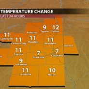
Predicted rainfall totals over the next 7 days. Starkville, Mississippi could receive 1.25-1.75 inches of rainfall from Thursday-Wednesday. (February 29-March 6) REMAINDER OF TODAY: Temperatures have shifted to the cooler side since the start of the week. After starting the workweek with warmer temperatures, we are in the low 50s due to a strong cold front passing through yesterday, putting us well below the average high of 63. We are about ten degrees below that number with our Thursday high only hitting 54. Additionally, northeast winds gusting up to 20 mph are making it feel cooler than the low 50s. TONIGHT AND TOMORROW: The Golden Triangle area will continue to have cooler temperatures into the overnight hours, with a low of 43. A chance of rain is expected after midnight but predicted rainfall totals are only expected to accumulate to about a tenth of an inch for this round. However, Friday presents itself to be a rather wet day because of a low-pressure trough, bringing with it a decent amount of moisture. As a result, the chance of rain is 90%, along with some embedded thunderstorms being possible. High temperatures on Friday will top out in the mid-50s, with a low in the upper 40s. WEEKEND AHEAD: Thanks to dominating southerly winds, expect the first weekend of March to have warm days and comfortable nights. Temperatures during the day are expected to reach the 70s before dropping down to the 50s at night. Saturday will be our best day to be outside as we have minimal rain chances and mostly sunny skies. However, we will have some rain to deal with as we close out our weekend on Sunday, with the best chance of rain beginning in the afternoon hours. That rain will be widespread throughout all of Sunday afternoon, so be sure to keep an umbrella handy if you are going out for any activities. Weekend planner for this weekend in Starkville, Mississippi. Saturday looks to be the better day, with Sunday having showers and storms. WET PATTERN CONTINUES: WORKWEEK The beginning of next week starts relatively dreary, with those showers sticking with us through the early morning hours of Monday. You may even hear a few rumbles of thunder as some thunderstorms could be included in that round of showers. A cold front is expected to pass through late Monday night into Tuesday morning, bringing us some more chances of wet weather. This cold front will allow for the continuation of wet conditions and an unstable weather pattern into Wednesday. It would be smart to have your umbrella and rain jacket handy throughout the duration of those days. Temperatures should be relatively comfortable, though, with highs in the upper 60s and lows in the upper 40s on Tuesday and Wednesday. Student Meteorologist, Nic...
read moreBreezy Week Ahead with Rain and Cool Temperatures Making Return by Midweek
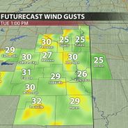
Wind gusts in northeast Mississippi could exceed 30 mph, particularly on Tuesday. After a week of pleasant temperatures and dry conditions due to high pressure and upper-level ridging, change is coming to northeast Mississippi. A strong upper-level jet has resulted in the formation of an upper-level trough and low-pressure system followed by a strong cold front. This system is currently moving across western and midwestern portions of the United States. By Wednesday, it will make its way into northeast Mississippi bringing gusty winds, colder temperatures, and rainfall. Tonight and Tomorrow: Last week’s pattern of warm days, cool nights, and dry conditions will continue throughout this evening and Tuesday. Tonight, those low temperatures will be around 60, making for a comfortable evening. Winds could gust up to 25 mph, so it will be breezy. Cloud coverage will begin to increase late tonight and stick around through the rest of the workweek. Tuesday looks to be the warmest and most spring-like day that northeast Mississippi will have experienced this year with highs reaching near 80 and lows in the low 60s. Once again, strong wind gusts will be around, gusting up to 35 mph throughout the afternoon and evening. Other than being breezy, baseball conditions will be great for the Mississippi State game against Jackson State. Enjoy this weather on Tuesday while you can because Wednesday will start a period of more unsettled weather conditions and cooler temperatures. Remainder of Workweek: Wednesday will bring us our next major weathermaker. A low-pressure system will allow for the development of thunderstorms in Mississippi on Wednesday as it meets warm and moist air from the Gulf of Mexico. Currently, severe weather is not expected, but strong, gusty winds will continue to be an issue until the passage of the cold front. The main line of storms looks to arrive in northeast Mississippi in the early morning hours, with scattered showers sticking around throughout the rest of the day. As with Monday and Tuesday, wind gusts are expected to reach near 30 mph. Wednesday will be a warm day with temperatures peaking in the low 70s, but following the storm system’s exit will be low temperatures in the upper 30s for Wednesday night. Thursday will start breezy with wind gusts reaching near 20 mph, but calmer conditions will take over in the afternoon. While wind speeds on Thursday are expected to be lower, so are the temperatures. They are only expected to reach the mid-50s in the afternoon and drop to the low 40s overnight. Scattered showers are possible late Thursday evening and throughout the day on Friday. Friday will bring a similar temperature pattern, with highs reaching near 60 but dropping to near 50 overnight. A strong cold front will be pushing through northeast Mississippi early Wednesday morning. A line of showers and thunderstorms will impact the area early Wednesday morning. Weekend/Early Next Week: The weekend will bring warmer temperatures and dry conditions to northeast Mississippi, with highs on both days expected to reach near 70, with lows in the mid-50s. This warming trend is expected to continue into next week, with temperatures reaching the low 70s and dropping to the upper 40s. Models currently have a low-pressure system bringing rain to the area to begin the next workweek. Student Meteorologist, Austin...
read moreFrom Warm to Warmer: Seasonal and Climatological pattern shifts reinforce spring temperatures
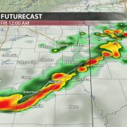
Tonight and Tomorrow: A quick-moving cold front will deliver scattered showers and the potential for a couple of strong storms late tonight into the early morning hours of Friday. The Storm Prediction Center (SPC) has placed north Mississippi underneath a (⅕) marginal risk for severe storms as a couple of storms have the potential to produce strong winds. Once the front moves through northeast Mississippi, it will reinforce dry, sunny, and breezy conditions on Friday and into the weekend. Winds will shift from the north around 10 mph with gusts near 20 mph. Friday afternoon, high temperatures should climb into the mid-to-upper 60s. Futurecast showing a couple of gusty storms possible late tonight into early Friday morning. Storm Prediction Center (SPC) highlights north Mississippi under a marginal risk outlook for severe weather tonight into early Friday morning. A Perfect Spring Weekend: It will certainly feel like spring this weekend. High temperatures will reach the low- to mid-60s on Saturday and low 70s on Sunday. Sustained winds of 10 to 15 mph with gusts from 20 to 25 mph will persist throughout the weekend as the low-pressure system continues to track eastward. The dry, sunny, and breezy afternoon conditions will make for a perfect weekend to head to Dudy Noble Field to watch the Bulldogs take on Georgia Southern. This weekend’s outlook. Next Week: A building ridge of high pressure will result in even warmer weather by early next week. Afternoon highs look to reach the mid-to-upper 70s on Monday and possibly near 80 for some areas on Tuesday. We remain dry and warm until our next cold front, which looks to arrive Wednesday into early Thursday, bringing the next chance for showers and T-storms. The SPC has already placed northeast Mississippi under a (⅖) slight risk for severe weather. Climate Outlook: La Niña forecast to make a return Not only do seasonal patterns drive our local weather, but so do global patterns. Just a few degrees difference in sea surface temperatures in the Pacific Ocean can change the climatological pattern, impacting the local weather in northeast Mississippi. In fact, we’ve experienced the influence of El Niño for almost a year, bringing a wet and chilly winter. But, the collapse of El Niño is well underway. The National Oceanic and Atmospheric Administration (NOAA) has officially declared a La Niña Watch as odds suggest La Niña will develop in June-August 2024. So, what does this mean for us in northeast Mississippi? Typically, La Niña brings conditions opposite to El Niño, meaning we expect dry and warmer conditions ahead. However, the more concerning impact of La Niña is the influence on hurricane season. The La Niña pattern allows for a much more conducive environment for tropical development, which could directly impact the Gulf Coast and increase the potential of northeast Mississippi being in the path of a storm. Hurricane season forecasts will start to come out over the next few months, and the first day of the season is June 1. Student Meteorologist, Sydney...
read moreAbove Average Temperature Stick Around through Weekend
High temperatures this week are going to reach the mid-60s and lower 70s. Warmer air is coming in from the south and will increase our temperatures for the week ahead. WORK WEEK AHEAD Tonight, it will be mostly clear with a calm wind. Temperatures will drop quickly into the overnight hours. Clear skies will let the heat escape after sundown. The temperature will drop near freezing in the Golden Triangle, 35° in Jackson and 42° in Gulfport tonight. Most of northeast Mississippi will be experiencing low- to mid-30s during the overnight hours. These temperatures will be just below the average low for this time of year. Temperatures will begin to rise this week, so take advantage of it and enjoy the warm sun. Tuesday will be very comfortable reaching 65° in Starkville and the upper 60s just to the south in Jackson. Don’t forget your blanket on Tuesday and Wednesday during the late afternoon if you plan on attending the Mississippi State’s baseball games against Austin Peay. Temperatures will start pleasant and drop to 39° as the sun goes down on Tuesday night. Spring-like temperatures will continue to rise into Wednesday reaching 73° in the Golden Triangle. It will be mostly sunny along with a nice breeze and a low of 55° in Starkville into Thursday. Thursday, there is a possibility of some scattered showers after noon. Along with these showers, there will be winds—mostly in the 10-15 mph range—along with some 35 mph gusts. A higher likelihood of scattered showers and thunderstorms will be Thursday night going into Friday morning. Thursday’s low will be around 47° with winds around 10-15 mph and some gusts around 25 mph. WEEKEND OUTLOOK Friday, a high-pressure system will move in and push out the rain chances for the weekend. Friday will be a little cooler than the beginning of the week with sunny skies, a breeze including 20 mph gusts, and a high of 66°. Friday night, the sky will be mostly clear with a low of 40°. Saturday and Sunday will turn out to be perfect days to head outside and enjoy the sun. Saturday’s high will be near 69° with a mostly sunny sky, clouds clearing out by the overnight hours, and a low of 42°. Sunday’s temperatures will be nice with plenty of sunshine, reaching 72° with sunny skies and a low of 50°. These lows are mild for this time of year. LONG TERM After the high-pressure system builds in on Friday, northeast Mississippi will likely remain above average in temperature for the 6-10 days after this week, as shown by the graphic below from the Climate Prediction Center. The average for this time of year is in the low-60s, and there is a good chance our area will stay above that mark in the foreseeable future, possibly until the start of March. Northeast Mississippi will continue the warming trend into the end of the...
read moreCold for baseball opening weekend, warmup to follow
Temperatures have warmed up nicely this week. Changes are on the way starting tonight. Clouds are beginning to build ahead of a cold front. The big story this weekend is the cold weather that will return.I want to start off with a story that our students have been highlighting for months—the extended period of drought. As of this morning, Mississippi’s drought has been almost eliminated. This is according to the latest map from the National Drought Mitigation Center. After 3” of rain this weekend in the Starkville area, Starkville is no longer categorized in any kind of drought. Late last year, 100% of the state was under at least a severe (2 out of 4) drought. 50% was under the worst category of drought (4 out of 4). Now, those numbers are 13% and 0% respectively. SHORT TERMTonight will be mild. Temperatures on campus will fall to about 50°. Surrounding rural areas should fall between 45 and 47°. Normal for this time of year is 36°. Winds will become breezy from the south at about 10-15 mph as a front nears.A Gulf Low will track to our south. This will help draw a quick-moving cold front over us Friday overnight. Mississippi State’s opening day for baseball against the Air Force should be dry, with temperatures near 70° and a cloudy sky. Most rain, as pictured, will be in the Gulf—maybe 0.25”-0.50” at best in northeast Mississippi.If you have evening plans Friday, plan to keep a rain jacket handy. Rain – with maybe a rumble of thunder or two – will push in through the early dawn hours on Saturday. There’s a chance you are asleep while it passes over. Saturday is not going to be a great baseball day. Some would call it football weather. Temperatures will struggle to get to the mid-40s. Highs will likely stay near 42°. It will be a raw day with clouds and breezy winds up to 20-25 mph. There will be nothing substantial rain-wise past about 8am.The sun will come back out on Sunday. We will start off with the coldest temperatures we’ve had in weeks – the upper 20s. Highs will peak in the low 50s.LONG TERMHigh pressure will build in next week. Clear skies will hold. Monday morning will be especially chilly with lows in the mid-20s.By Monday afternoon, temperatures will be near 60°. We will keep the warming trend going. By Friday, highs will climb to the lower 70s. It will be very mild.There is a consistent pattern going on. The pattern is warmer for 4-5 days, and then there is a chance for rain. Afterwards, there is a brief return to cooler weather before it gets warmer once again.Temperatures have been 4-5° above average so far this month. That should still be the case when we wrap it up on the...
read moreScattered Showers Today, Clearing Out Mid-Week
Overcast and dreary to start off the next work week! Heavy cloud coverage will stick around for the remainder of the day. Scattered showers and a few storms are likely through the day as an area of low pressure makes its way across northern Mississippi. It will be slightly cooler today with temperatures ranging from the mid 50s to low 60s across the region this afternoon. Winds will quickly begin to pick up as we head into the afternoon and evening hours, so expect a breezy evening. Wind gusts could possibly exceed 20-25 mph at times. Heading into the overnight hours, clouds will linger until just after midnight tonight. We’ll see a drop in temperatures starting tonight with overnight lows in the middle to upper 30s. Drier days ahead! As the showers and storms clear out of the area by early Tuesday, high pressure builds into the region to give us much nicer weather for the next few days. Cooler conditions are expected for our Tuesday with highs only reaching the mid 50s for the afternoon. Chilly mornings continue through Thursday with morning temperatures in the mid 30s. Temperatures return to the 60s for the next few days with plenty of sunshine, so pleasant conditions for any outdoor plans you have! Looking ahead to the end of the work week, we have our next system making its way into northern Mississippi. A southwesterly flow allows for more moisture and instability which will help to increase rain chances for Friday and Saturday. There will be a steady increase in cloud coverage throughout the day on our Friday that will bring additional showers for Friday night into Saturday. As of right now, rain totals do not look as impressive as this past weekend’s. Things will dry out by Sunday to give us mostly sunny skies and a pleasant afternoon. Colder air is expected to move in for Saturday evening and Sunday, so be prepared for a chilly start as you step out the door Sunday morning. Temperatures will be more seasonal heading into the beginning of the next work week with highs in the mid 50s and lows in the upper 20s to mid 30s. Campus Connect Weather Meteorologist McKinley...
read moreWet Weekend Ahead Brings More Seasonal Temperatures
Hope everyone is having a great week! The weather sure has been wonderful these past few days with sunshine and warm temperatures well into the 60s. As of Thursday afternoon, satellite and radar shows high clouds building into northeast Mississippi ahead of our next storm system. It’s also a bit breezy as winds are now gusting up to 20 mph from the south which will aid in transporting plenty of moisture our way. Tonight, we’ll remain dry with temperatures remaining warm in the mid-upper 50s with a few scattered rain showers developing. These will continue into our Friday and become more frequent throughout the late morning and early afternoon. Amidst the rain and clouds, temperatures will still manage to near the 70° mark on Friday with noticeably more muggy conditions in place as well. The weekend ahead looks nasty in terms of any outdoors plans. As a stationary front stalls to our north, several waves of energy will ride along it, each bringing another chance for rain between Friday and Monday. However, it will not be raining the entire time and there are no threats for any flooding. The most notable and perhaps consistent period of rain looks to arrive on Saturday afternoon, lasting into Sunday morning as heavier rain develops to our southwest and rides along that front into northeast Mississippi. Most of Saturday morning and Sunday afternoon appear to be dry with only a few scattered rain showers passing through. The GFS Future-cast model below shows these repeated rounds of showers and periodic steady rain. The good news is temperatures will continue to remain above average in the upper 60s which is much better than a cold rain! Moving into our next work week, the stationary front bringing us the weekend rain will eventually pass through as a cold front late Sunday night and early Monday, providing another chance for widespread rain and likely tallying up our total weekend rainfall to 1-2”. This front will also swing in some cooler temperatures with highs back in the upper 50s and lows in the lower 30s next Monday through Wednesday. Although this may seem chilly, we will be back near our average and exactly where we should be for the first half of February. Thankfully, sunshine will accompany this cooler period, and temperatures will begin to migrate back to that 60° mark by mid-late next week. Campus Connect WeatherMeteorologist Jacob WoodsTwitter:...
read more